 Loading... Please wait...
Hydrological Equipment
NEWS RELEASE
Cost and Accuracy Comparisons
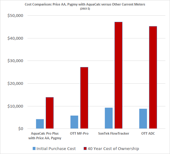
Mechanical Current Meter System with AquaCalc Versus Other Point Velocity Discharge Systems
Download PDF
Surveying
 Discharge measurement data is irrelevant and inaccurate if correct station levels are not set and maintained. A USGS standard gaging station has a minimum of three elevation references and a typical station would have four reference marks and six elevations referenced to gage datum for redundancy and convenience to perform stage elevation checks. The USGS standards require a yearly check of gage datum levels so that any reference movement, settling, etc. can be noted and corrected. All reference marks are surveyed in at .001 feet while gage datums are read to .01 feet.
Automatic levels or total stations are used to set accurate elevations for permanent gaging stations. Hand levels are typically used for initial field site selection and stream habitat surveys. Also stream hydraulic gradient measurements can be obtained with a hand level or clinometer. Level rods, tripods and other surveying accessories are offered to complete the necessary measurement and various markers and nails are used for setting reference marks.